QuikGrid
Create surfaces with a 3D appearance using a grid

- Category Geography
- Program license Free
- Version 5.3
- Size 494.73 kB
- Works under: Windows 95
- Program available in English
- Program by Perspectiveedge
QuikGrid is a free data visualization program that lets you render a 3D surface from data points.
How often have you wanted to visualize your datasets into an easy-to-understand 3D surface? With QuikGrid you can do just that!
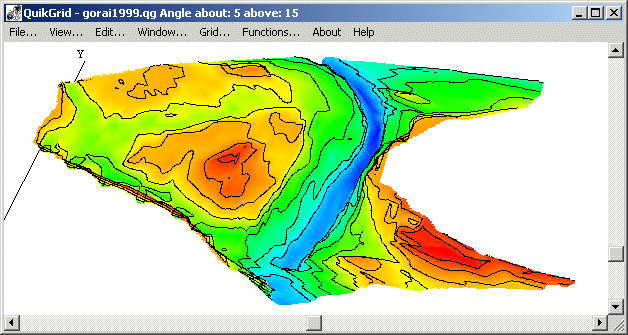
This program reads a set of scattered data points on a 3D axis (x, y, z) which will represent the “surface” of your model. From there the program extrapolates a grid from your data and creates a visualization either as a 3D model or as a contour "heat map" that ranges in color from blue to red depending on your data.
Just like with other 3D software, you’ll be able to use your left click to pan around the data visualization as well as zoom, and the right click gives you more information about what you’re looking at (think “right click – properties”, for example).
Built to run even on legacy hardware, you’ll be able to render a 400x400 grid with 30,000 data points in around 5 seconds on an old Pentium 2 computer! Designed with modest hardware in mind, this tool is ideal for students, educators and others that want to visualize their data.
It’s important to note that this software is no longer under active development and you may run into some minor issues when running it on newer computers. The help files may not work on Vista, Windows 7 and Windows 10 machines because late-gen products use a different help-file system. You can solve this by installing the Microsoft HTML Workshop tool.
Users on 64bit PCs will want to make sure they’re getting the 64bit version of the program – this will allow you to map over 100,000,000 points of data with similarly fast render times as the 32bit lite version of QuikGrid.
As the program is a GNU licensed project, users are able to get full access to the source code via the QuikGrid developer’s website which can be found on Google.
So if you’re searching for a way to visualize datasets both large and small, you’ll be hard pressed to find a tool that works this well on even the most modest of hardware.
Pros
- Runs on Old Hardware, Even Pentium 1! Is your academic department still running Windows 98? Don’t worry, this program will run on anything as long as it’s Windows and has enough processing power to compute (the developer recommends a minimum or 300MHz and 32MB of ram).
- Updated to Work with 64bit Machines The program was built during the latent 32bit development cycle was at its peak, but others have picked up the torch and upgraded the code to handle 64bit machines processing visualizations of >100,000,000 datapoints.
- Free and GNU The program will be free forever, and GNU licensing guarantees that someone will continue to develop the program as long as it’s useful to someone.
Cons
- No Longer Being Developed The main developer abandoned Windows many years ago, so support from them is extremely limited.